


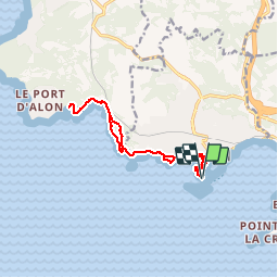
Bandol - Port d'Alon

soca
User

Length
12.8 km

Max alt
84 m

Uphill gradient
256 m
Km-Effort
16.2 km

Min alt
-4 m

Downhill gradient
257 m
Boucle
Yes
Creation date :
2019-09-10 16:53:29.289
Updated on :
2019-09-10 16:54:37.228
4h30
Difficulty : Medium

FREE GPS app for hiking
 SityTrail
IGN / Geographical institutes
SityTrail Plus
The world is yours!
About
Trail On foot of 12.8 km to be discovered at Provence-Alpes-Côte d'Azur, Var, Bandol. This trail is proposed by soca.
Positioning
Country:
France
Region :
Provence-Alpes-Côte d'Azur
Department/Province :
Var
Municipality :
Bandol
Location:
Unknown
Start:(Dec)
Start:(UTM)
723738 ; 4778983 (31T) N.
Comments