


SityTrail - 09.07.2019 - de SION les MINES à ST AUBIN DES CHÂTEAUX

chasle
User
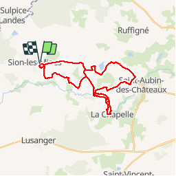

Length
30 km

Max alt
82 m

Uphill gradient
261 m
Km-Effort
33 km

Min alt
30 m

Downhill gradient
260 m
Boucle
Yes
Creation date :
2019-09-11 18:07:34.235
Updated on :
2019-09-11 18:07:34.235

FREE GPS app for hiking
 SityTrail
IGN / Geographical institutes
SityTrail Plus
The world is yours!
About
Trail of 30 km to be discovered at Pays de la Loire, Loire-Atlantique, Sion-les-Mines. This trail is proposed by chasle.
Positioning
Country:
France
Region :
Pays de la Loire
Department/Province :
Loire-Atlantique
Municipality :
Sion-les-Mines
Location:
Unknown
Start:(Dec)
Start:(UTM)
605992 ; 5287658 (30T) N.
Comments