


Mont du Marseillais

soca
User
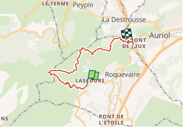

Length
11.3 km

Max alt
606 m

Uphill gradient
565 m
Km-Effort
19 km

Min alt
174 m

Downhill gradient
620 m
Boucle
No
Creation date :
2019-09-12 05:34:33.541
Updated on :
2020-10-26 10:18:33.033
4h00
Difficulty : Medium

FREE GPS app for hiking
 SityTrail
IGN / Geographical institutes
SityTrail Plus
The world is yours!
About
Trail On foot of 11.3 km to be discovered at Provence-Alpes-Côte d'Azur, Bouches-du-Rhône, Roquevaire. This trail is proposed by soca.
Positioning
Country:
France
Region :
Provence-Alpes-Côte d'Azur
Department/Province :
Bouches-du-Rhône
Municipality :
Roquevaire
Location:
Unknown
Start:(Dec)
Start:(UTM)
709126 ; 4802171 (31T) N.
Comments