


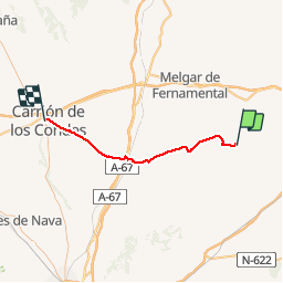
Castrojeriz Cyclisme

famiski
User

Length
50 km

Max alt
855 m

Uphill gradient
460 m
Km-Effort
56 km

Min alt
763 m

Downhill gradient
427 m
Boucle
No
Creation date :
2019-09-12 08:37:35.429
Updated on :
2019-09-12 08:38:05.761

FREE GPS app for hiking
 SityTrail
IGN / Geographical institutes
SityTrail Plus
The world is yours!
About
Trail of 50 km to be discovered at Castile and León, Unknown, Castrojeriz. This trail is proposed by famiski.
Positioning
Country:
Spain
Region :
Castile and León
Department/Province :
Unknown
Municipality :
Castrojeriz
Location:
Unknown
Start:(Dec)
Start:(UTM)
406779 ; 4682757 (30T) N.
Comments