


Vallée de goy en

robinier
User
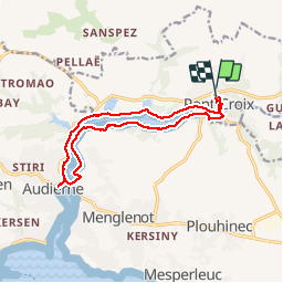

Length
13.2 km

Max alt
42 m

Uphill gradient
201 m
Km-Effort
15.8 km

Min alt
0 m

Downhill gradient
201 m
Boucle
Yes
Creation date :
2019-09-12 07:06:40.0
Updated on :
2019-09-12 12:08:57.083
4h56
Difficulty : Unknown

FREE GPS app for hiking
 SityTrail
IGN / Geographical institutes
SityTrail Plus
The world is yours!
About
Trail Walking of 13.2 km to be discovered at Brittany, Finistère, Pont-Croix. This trail is proposed by robinier.
Positioning
Country:
France
Region :
Brittany
Department/Province :
Finistère
Municipality :
Pont-Croix
Location:
Unknown
Start:(Dec)
Start:(UTM)
389003 ; 5322094 (30U) N.
Comments