


Vallon allées

A-M Lubin
User
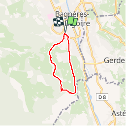

Length
4.7 km

Max alt
671 m

Uphill gradient
145 m
Km-Effort
6.6 km

Min alt
556 m

Downhill gradient
145 m
Boucle
Yes
Creation date :
2019-09-12 11:12:23.412
Updated on :
2019-09-12 12:33:00.273
1h14
Difficulty : Very easy

FREE GPS app for hiking
 SityTrail
IGN / Geographical institutes
SityTrail Plus
The world is yours!
About
Trail Walking of 4.7 km to be discovered at Occitania, Hautespyrenees, Bagnères-de-Bigorre. This trail is proposed by A-M Lubin.
Positioning
Country:
France
Region :
Occitania
Department/Province :
Hautespyrenees
Municipality :
Bagnères-de-Bigorre
Location:
Unknown
Start:(Dec)
Start:(UTM)
268013 ; 4771673 (31T) N.
Comments