


bouclelocquignol

svp59
User
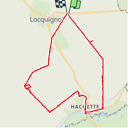

Length
20 km

Max alt
181 m

Uphill gradient
202 m
Km-Effort
23 km

Min alt
129 m

Downhill gradient
201 m
Boucle
Yes
Creation date :
2014-12-10 00:00:00.0
Updated on :
2014-12-10 00:00:00.0
4h26
Difficulty : Easy

FREE GPS app for hiking
 SityTrail
IGN / Geographical institutes
SityTrail Plus
The world is yours!
About
Trail Walking of 20 km to be discovered at Hauts-de-France, Nord, Locquignol. This trail is proposed by svp59.
Description
via la Hachette Arboretum étang David
Photos


Positioning
Country:
France
Region :
Hauts-de-France
Department/Province :
Nord
Municipality :
Locquignol
Location:
Unknown
Start:(Dec)
Start:(UTM)
552206 ; 5561095 (31U) N.
Comments