


Landévennec - boucles locales et GR34 - 13.8km 250m 4h10 (35mn) - 2019 09 12

Orcal37
User GUIDE
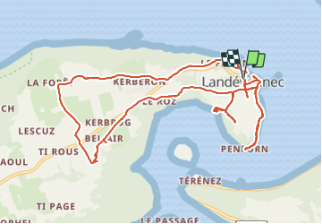

Length
13.8 km

Max alt
117 m

Uphill gradient
254 m
Km-Effort
17.2 km

Min alt
0 m

Downhill gradient
255 m
Boucle
Yes
Creation date :
2019-09-12 10:41:54.152
Updated on :
2021-09-19 17:55:14.417
4h10
Difficulty : Easy

FREE GPS app for hiking
 SityTrail
IGN / Geographical institutes
SityTrail Plus
The world is yours!
About
Trail Walking of 13.8 km to be discovered at Brittany, Finistère, Landévennec. This trail is proposed by Orcal37.
Description
Landévennec - boucles locales et GR34 - 13.8km 250m 4h10 (35mn) - 2019 09 12
Photos
 - 2019 09 12 - Photo 1")
 - 2019 09 12 - Photo 2")
 - 2019 09 12 - Photo 3")
 - 2019 09 12 - Photo 4")
 - 2019 09 12 - Photo 5")
 - 2019 09 12 - Photo 6")
Positioning
Country:
France
Region :
Brittany
Department/Province :
Finistère
Municipality :
Landévennec
Location:
Unknown
Start:(Dec)
Start:(UTM)
405961 ; 5349636 (30U) N.
Comments