


jour 4

AMOURETTE
User
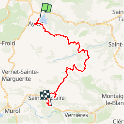

Length
26 km

Max alt
951 m

Uphill gradient
607 m
Km-Effort
34 km

Min alt
666 m

Downhill gradient
787 m
Boucle
No
Creation date :
2019-09-12 06:15:28.72
Updated on :
2019-09-12 19:33:47.929
9h32
Difficulty : Very easy

FREE GPS app for hiking
 SityTrail
IGN / Geographical institutes
SityTrail Plus
The world is yours!
About
Trail Walking of 26 km to be discovered at Auvergne-Rhône-Alpes, Puy-de-Dôme, Aydat. This trail is proposed by AMOURETTE.
Positioning
Country:
France
Region :
Auvergne-Rhône-Alpes
Department/Province :
Puy-de-Dôme
Municipality :
Aydat
Location:
Unknown
Start:(Dec)
Start:(UTM)
498602 ; 5056916 (31T) N.
Comments