


aaa

orsel
User GUIDE
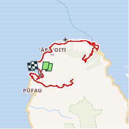

Length
44 km

Max alt
320 m

Uphill gradient
1012 m
Km-Effort
57 km

Min alt
0 m

Downhill gradient
1011 m
Boucle
Yes
Creation date :
2019-09-07 18:36:01.593
Updated on :
2019-09-12 23:48:41.045
119h43
Difficulty : Very easy

FREE GPS app for hiking
 SityTrail
IGN / Geographical institutes
SityTrail Plus
The world is yours!
About
Trail Walking of 44 km to be discovered at Unknown, Leeward Islands, Tumaraa. This trail is proposed by orsel.
Positioning
Country:
France
Region :
Unknown
Department/Province :
Leeward Islands
Municipality :
Tumaraa
Location:
Tevaitoa
Start:(Dec)
Start:(UTM)
661684 ; 8147715 (5K) S.
Comments