


sous de très G3 FAIT

LouisROGER
User GUIDE

Length
11.6 km

Max alt
978 m

Uphill gradient
604 m
Km-Effort
19.7 km

Min alt
427 m

Downhill gradient
601 m
Boucle
Yes
Creation date :
2019-09-13 07:12:46.134
Updated on :
2019-09-13 14:32:55.057
6h27
Difficulty : Very easy

FREE GPS app for hiking
 SityTrail
IGN / Geographical institutes
SityTrail Plus
The world is yours!
About
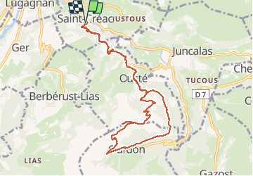
Trail Walking of 11.6 km to be discovered at Occitania, Hautespyrenees, Saint-Créac. This trail is proposed by LouisROGER.
Photos


Positioning
Country:
France
Region :
Occitania
Department/Province :
Hautespyrenees
Municipality :
Saint-Créac
Location:
Unknown
Start:(Dec)
Start:(UTM)
742295 ; 4771619 (30T) N.
Comments