


13 septembre 2019 col de malpertus

Parodie69
User

Length
15.7 km

Max alt
1342 m

Uphill gradient
861 m
Km-Effort
27 km

Min alt
523 m

Downhill gradient
864 m
Boucle
Yes
Creation date :
2019-09-13 07:39:55.097
Updated on :
2019-09-13 15:00:07.095
7h19
Difficulty : Difficult

FREE GPS app for hiking
 SityTrail
IGN / Geographical institutes
SityTrail Plus
The world is yours!
About
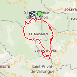
Trail Walking of 15.7 km to be discovered at Occitania, Lozère, Pont de Montvert - Sud Mont Lozère. This trail is proposed by Parodie69.
Positioning
Country:
France
Region :
Occitania
Department/Province :
Lozère
Municipality :
Pont de Montvert - Sud Mont Lozère
Location:
Unknown
Start:(Dec)
Start:(UTM)
566101 ; 4907529 (31T) N.
Comments