


20190913vin

Jeanclaudebic
User

Length
26 km

Max alt
228 m

Uphill gradient
143 m
Km-Effort
28 km

Min alt
70 m

Downhill gradient
274 m
Boucle
No
Creation date :
2019-09-13 13:25:13.403
Updated on :
2019-09-13 16:47:08.869
3h21
Difficulty : Very easy

FREE GPS app for hiking
 SityTrail
IGN / Geographical institutes
SityTrail Plus
The world is yours!
About
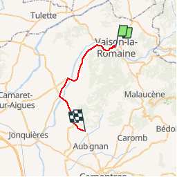
Trail Walking of 26 km to be discovered at Provence-Alpes-Côte d'Azur, Vaucluse, Vaison-la-Romaine. This trail is proposed by Jeanclaudebic.
Positioning
Country:
France
Region :
Provence-Alpes-Côte d'Azur
Department/Province :
Vaucluse
Municipality :
Vaison-la-Romaine
Location:
Unknown
Start:(Dec)
Start:(UTM)
665541 ; 4900721 (31T) N.
Comments