


massaguel,pas du sant,le lampy arfons massaguel

Dupleix
User
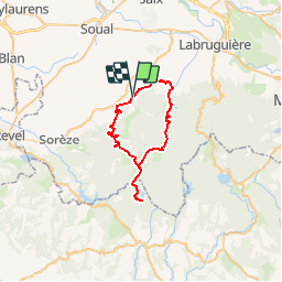

Length
41 km

Max alt
783 m

Uphill gradient
1186 m
Km-Effort
57 km

Min alt
256 m

Downhill gradient
1181 m
Boucle
Yes
Creation date :
2019-09-13 16:55:53.773
Updated on :
2019-09-13 16:57:46.835
--
Difficulty : Very easy

FREE GPS app for hiking
 SityTrail
IGN / Geographical institutes
SityTrail Plus
The world is yours!
About
Trail Cycle of 41 km to be discovered at Occitania, Tarn, Massaguel. This trail is proposed by Dupleix.
Description
rude boucle
Positioning
Country:
France
Region :
Occitania
Department/Province :
Tarn
Municipality :
Massaguel
Location:
Unknown
Start:(Dec)
Start:(UTM)
432087 ; 4815824 (31T) N.
Comments