


Italie repas

JPS73
User
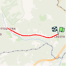

Length
6 km

Max alt
1095 m

Uphill gradient
149 m
Km-Effort
7.9 km

Min alt
1042 m

Downhill gradient
146 m
Boucle
Yes
Creation date :
2019-09-05 08:04:16.653
Updated on :
2019-09-14 11:23:32.519
1h54
Difficulty : Very easy

FREE GPS app for hiking
 SityTrail
IGN / Geographical institutes
SityTrail Plus
The world is yours!
About
Trail Walking of 6 km to be discovered at Piemont, Torino, Giaglione. This trail is proposed by JPS73.
Positioning
Country:
Italy
Region :
Piemont
Department/Province :
Torino
Municipality :
Giaglione
Location:
Unknown
Start:(Dec)
Start:(UTM)
342290 ; 5000486 (32T) N.
Comments