


Beaucroissant

meillon
User
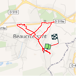

Length
4.2 km

Max alt
442 m

Uphill gradient
31 m
Km-Effort
4.7 km

Min alt
411 m

Downhill gradient
57 m
Boucle
No
Creation date :
2019-09-14 10:27:54.472
Updated on :
2019-09-14 13:02:54.612
2h34
Difficulty : Very easy

FREE GPS app for hiking
 SityTrail
IGN / Geographical institutes
SityTrail Plus
The world is yours!
About
Trail Walking of 4.2 km to be discovered at Auvergne-Rhône-Alpes, Isère, Beaucroissant. This trail is proposed by meillon.
Description
foire bcp de monde !
Positioning
Country:
France
Region :
Auvergne-Rhône-Alpes
Department/Province :
Isère
Municipality :
Beaucroissant
Location:
Unknown
Start:(Dec)
Start:(UTM)
693877 ; 5023407 (31T) N.
Comments