


Le Hongrie depuis l'aéroclub

PatriceCocuaud
User
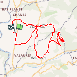

Length
29 km

Max alt
1190 m

Uphill gradient
898 m
Km-Effort
41 km

Min alt
529 m

Downhill gradient
898 m
Boucle
Yes
Creation date :
2019-09-14 14:52:30.882
Updated on :
2019-09-14 18:02:30.499
2h48
Difficulty : Medium

FREE GPS app for hiking
 SityTrail
IGN / Geographical institutes
SityTrail Plus
The world is yours!
About
Trail Mountain bike of 29 km to be discovered at Provence-Alpes-Côte d'Azur, Alpes-de-Haute-Provence, Vaumeilh. This trail is proposed by PatriceCocuaud.
Positioning
Country:
France
Region :
Provence-Alpes-Côte d'Azur
Department/Province :
Alpes-de-Haute-Provence
Municipality :
Vaumeilh
Location:
Unknown
Start:(Dec)
Start:(UTM)
734024 ; 4907394 (31T) N.
Comments