


ravin des arcs

xav34830
User
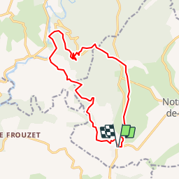

Length
16.2 km

Max alt
332 m

Uphill gradient
498 m
Km-Effort
23 km

Min alt
106 m

Downhill gradient
499 m
Boucle
Yes
Creation date :
2014-12-10 00:00:00.0
Updated on :
2014-12-10 00:00:00.0
4h57
Difficulty : Easy

FREE GPS app for hiking
 SityTrail
IGN / Geographical institutes
SityTrail Plus
The world is yours!
About
Trail Walking of 16.2 km to be discovered at Occitania, Hérault, Notre-Dame-de-Londres. This trail is proposed by xav34830.
Positioning
Country:
France
Region :
Occitania
Department/Province :
Hérault
Municipality :
Notre-Dame-de-Londres
Location:
Unknown
Start:(Dec)
Start:(UTM)
559689 ; 4851256 (31T) N.
Comments