


Roche longue

richardsimopons
User

Length
7.1 km

Max alt
10 m

Uphill gradient
26 m
Km-Effort
7.4 km

Min alt
-1 m

Downhill gradient
20 m
Boucle
No
Creation date :
2019-09-15 06:28:16.0
Updated on :
2019-09-15 08:38:38.511
1h51
Difficulty : Easy

FREE GPS app for hiking
 SityTrail
IGN / Geographical institutes
SityTrail Plus
The world is yours!
About
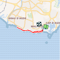
Trail Walking of 7.1 km to be discovered at Occitania, Hérault, Agde. This trail is proposed by richardsimopons.
Description
De Rochelongue vers Grau d’AGDE
Photos


Positioning
Country:
France
Region :
Occitania
Department/Province :
Hérault
Municipality :
Agde
Location:
Unknown
Start:(Dec)
Start:(UTM)
540219 ; 4791442 (31T) N.
Comments