


royer

XavierFaidix
User
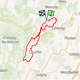

Length
26 km

Max alt
477 m

Uphill gradient
748 m
Km-Effort
36 km

Min alt
247 m

Downhill gradient
747 m
Boucle
Yes
Creation date :
2019-09-12 12:00:03.873
Updated on :
2019-09-15 08:39:58.505
3h00
Difficulty : Medium

FREE GPS app for hiking
 SityTrail
IGN / Geographical institutes
SityTrail Plus
The world is yours!
About
Trail Mountain bike of 26 km to be discovered at Bourgogne-Franche-Comté, Saône-et-Loire, Royer. This trail is proposed by XavierFaidix.
Positioning
Country:
France
Region :
Bourgogne-Franche-Comté
Department/Province :
Saône-et-Loire
Municipality :
Royer
Location:
Unknown
Start:(Dec)
Start:(UTM)
639727 ; 5157287 (31T) N.
Comments