


AL Esch sur Alzette

phugues
User
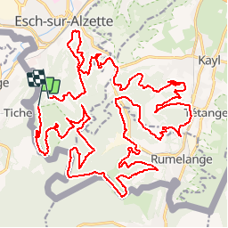

Length
36 km

Max alt
442 m

Uphill gradient
822 m
Km-Effort
47 km

Min alt
288 m

Downhill gradient
816 m
Boucle
No
Creation date :
2019-09-15 07:19:49.68
Updated on :
2019-09-15 10:02:46.863
2h42
Difficulty : Difficult

FREE GPS app for hiking
 SityTrail
IGN / Geographical institutes
SityTrail Plus
The world is yours!
About
Trail Mountain bike of 36 km to be discovered at Unknown, Canton Esch-sur-Alzette, Esch-sur-Alzette. This trail is proposed by phugues.
Positioning
Country:
Luxembourg
Region :
Unknown
Department/Province :
Canton Esch-sur-Alzette
Municipality :
Esch-sur-Alzette
Location:
Park
Start:(Dec)
Start:(UTM)
715559 ; 5484470 (31U) N.
Comments