


patrimoine réalisation

andre.rochet.ar
User

Length
2.9 km

Max alt
164 m

Uphill gradient
44 m
Km-Effort
3.5 km

Min alt
121 m

Downhill gradient
42 m
Boucle
Yes
Creation date :
2019-09-15 08:07:41.341
Updated on :
2019-09-15 12:59:55.545
1h39
Difficulty : Very easy

FREE GPS app for hiking
 SityTrail
IGN / Geographical institutes
SityTrail Plus
The world is yours!
About
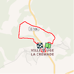
Trail Walking of 2.9 km to be discovered at Occitania, Aude, Fabrezan. This trail is proposed by andre.rochet.ar.
Description
Seconde randonnée dans Villerouge à l'occasion de la journée du patrimoine 2019
Positioning
Country:
France
Region :
Occitania
Department/Province :
Aude
Municipality :
Fabrezan
Location:
Unknown
Start:(Dec)
Start:(UTM)
478742 ; 4773292 (31T) N.
Comments