Trail Walking Cademario - caddemario -Mte Lema - Photo
 duamerg
duamerg

User

© OpenStreetMap contributors
Length
Length
18.4 km
Max alt
Max alt
1619 m
Uphill gradient
Uphill gradient
1373 m
Km-Effort
Km-Effort  
37 km
Min alt
Min alt
589 m
Downhill gradient
Downhill gradient
1373 m
Boucle
Boucle
Yes
Creation date :
2014-12-11 00:00:00.0
Updated on :
2020-01-30 13:58:38.355

(0 Reviews)

Walking
Walking
6h00
Difficulty : Difficult

Scan this QR Code to open this trail in the SityTrail application

FREE GPS app for hiking

Logo SityTrail SityTrail

IGN / Geographical institutes

Download SityTrail from the App Store Download SityTrail from Google Play

Logo SityTrail SityTrail World

The world is yours!

Download SityTrail from the App Store Download SityTrail from Google Play Download SityTrail on Huawei AppGallery

About

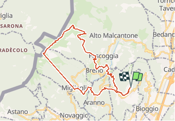
Trail Walking of 18.4 km to be discovered at Ticino, Distretto di Lugano, Cademario. This trail is proposed by duamerg.

Description

Du haut du village, prendre la direction du tennis puis descendre jusqu'à la rivière. Après le pont prendre à droite et monter jusqu''à Breno. Sortir du village (vers Vezio) avant de trouver une indication pour le Mte Lema. Après la fontaine, ne pas manquer une bifurcation qui mène à L'Alpe de Mageno. Continuer la montée pour trouver le chemin Mte Léma Tamaro. Suivre ce chemin jusqu'au Mte Bré. Prendre le téléphérique pour rejoindre Migleglia. Descendre à la rivière en suivant Aranno. Buvette au bord de la rivière. Forte montée sur Aranno. A la croisée de la route, rejoindre le chemin qui nous ramène sur Cademario.
Attention aux horaires des remontées mécaniques. Très longue course, donc considérée comme difficile!

Elevation profile

Positioning

Country:
Switzerland
Region :
Ticino
Department/Province :
Distretto di Lugano
Municipality :
Cademario
Location:
Unknown
Start:(UTM)
491955 ; 5096781 (32T) N.

Trails nearby

Trail On foot Paradiso - Paradiso-San Salvatore - Photo
On foot
PRO

On foot

Easy
Paradiso, Ticino, Distretto di Lugano, Switzerland
3.2 km | 9.1 km-effort
2h 3min
No
Trail Walking Lugano - Circuit decouverte Lugano - Photo
Walking
chessyca

Walking

Medium
Lugano, Ticino, Distretto di Lugano, Switzerland
25 km | 40 km-effort
5h 42min
Yes
Trail Other activity Paradiso - y10_hoehenweg_luganersee - Photo
Other activity
GUIDE+

Other activity

Very easy
Paradiso, Ticino, Distretto di Lugano, Switzerland
12.2 km | 22 km-effort
5h 16min
No
Trail Mountain bike Miglieglia - Pradecolo - Photo
Mountain bike
GUIDE+

Mountain bike

Very easy
Miglieglia, Ticino, Distretto di Lugano, Switzerland
27 km | 40 km-effort
12h 3min
Yes
Trail Mountain bike Lugano - Bike32933 - Photo
Mountain bike
GUIDE+

Mountain bike

Very easy
Lugano, Ticino, Distretto di Lugano, Switzerland
25 km | 38 km-effort
Unknown
Yes
Trail Mountain bike Magliaso - Bike32929 - Photo
Mountain bike
GUIDE+

Mountain bike

Very easy
Magliaso, Ticino, Distretto di Lugano, Switzerland
29 km | 44 km-effort
Unknown
Yes
Trail Walking Miglieglia - Tessiner Gratwanderung: Monte Lema - Monte Tamaro - Photo
Walking
GUIDE+

Walking

Very easy
Miglieglia, Ticino, Distretto di Lugano, Switzerland
17.6 km | 38 km-effort
Unknown
No
Trail Walking Alto Malcantone - Caslano: Kastanienweg - Photo
Walking
GUIDE+

Walking

Very easy
Alto Malcantone, Ticino, Distretto di Lugano, Switzerland
11.1 km | 16.4 km-effort
Unknown
No
Trail Walking Paradiso - Paradiso - San Salvatore - Carona - Morcote - Photo
Walking
GUIDE+

Walking

Very easy
Paradiso, Ticino, Distretto di Lugano, Switzerland
11.3 km | 19.9 km-effort
Unknown
No


Close
My subscriptions