


MN2AzereixFAIT

LouisROGER
User GUIDE
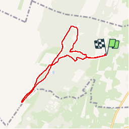

Length
8.5 km

Max alt
456 m

Uphill gradient
138 m
Km-Effort
10.3 km

Min alt
340 m

Downhill gradient
138 m
Boucle
Yes
Creation date :
2019-09-16 06:45:19.927
Updated on :
2019-09-16 09:16:25.579
2h30
Difficulty : Very easy

FREE GPS app for hiking
 SityTrail
IGN / Geographical institutes
SityTrail Plus
The world is yours!
About
Trail Nordic walking of 8.5 km to be discovered at Occitania, Hautespyrenees, Azereix. This trail is proposed by LouisROGER.
Positioning
Country:
France
Region :
Occitania
Department/Province :
Hautespyrenees
Municipality :
Azereix
Location:
Unknown
Start:(Dec)
Start:(UTM)
741967 ; 4788494 (30T) N.
Comments