


Marche Bleue 4 km Fère-en-Tardenois

VANDERPUTTENMi
User GUIDE
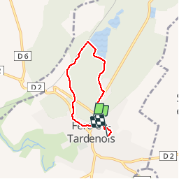

Length
4.2 km

Max alt
131 m

Uphill gradient
32 m
Km-Effort
4.6 km

Min alt
114 m

Downhill gradient
36 m
Boucle
No
Creation date :
2019-09-16 11:48:17.107
Updated on :
2019-09-16 14:54:59.314
50m
Difficulty : Very easy

FREE GPS app for hiking
 SityTrail
IGN / Geographical institutes
SityTrail Plus
The world is yours!
About
Trail Walking of 4.2 km to be discovered at Hauts-de-France, Aisne, Fère-en-Tardenois. This trail is proposed by VANDERPUTTENMi.
Positioning
Country:
France
Region :
Hauts-de-France
Department/Province :
Aisne
Municipality :
Fère-en-Tardenois
Location:
Unknown
Start:(Dec)
Start:(UTM)
537423 ; 5450063 (31U) N.
Comments