


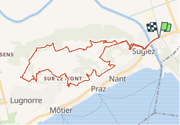
Tour du Vully

duamerg
User

Length
13.3 km

Max alt
650 m

Uphill gradient
471 m
Km-Effort
19.6 km

Min alt
427 m

Downhill gradient
471 m
Boucle
Yes
Creation date :
2014-12-11 00:00:00.0
Updated on :
2020-01-30 13:58:27.859
4h25
Difficulty : Easy

FREE GPS app for hiking
 SityTrail
IGN / Geographical institutes
SityTrail Plus
The world is yours!
About
Trail Walking of 13.3 km to be discovered at Fribourg, See District, Mont-Vully. This trail is proposed by duamerg.
Description
"Parquer vers la gare de Sugiez. Prendre à droite au coeur du village.
Positioning
Country:
Switzerland
Region :
Fribourg
Department/Province :
See District
Municipality :
Mont-Vully
Location:
Unknown
Start:(Dec)
Start:(UTM)
356824 ; 5202963 (32T) N.
Comments