


190918tt enery mantes

olivieraron
User
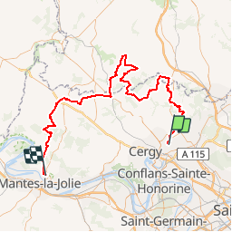

Length
103 km

Max alt
216 m

Uphill gradient
1256 m
Km-Effort
120 km

Min alt
42 m

Downhill gradient
1193 m
Boucle
No
Creation date :
2019-09-17 22:45:54.287
Updated on :
2019-09-17 22:49:38.511
--
Difficulty : Very easy

FREE GPS app for hiking
 SityTrail
IGN / Geographical institutes
SityTrail Plus
The world is yours!
About
Trail Motorbike of 103 km to be discovered at Ile-de-France, Val-d'Oise, Ennery. This trail is proposed by olivieraron.
Positioning
Country:
France
Region :
Ile-de-France
Department/Province :
Val-d'Oise
Municipality :
Ennery
Location:
Unknown
Start:(Dec)
Start:(UTM)
434940 ; 5435271 (31U) N.
Comments