


meyrueis

bouscaillou
User

Length
21 km

Max alt
1058 m

Uphill gradient
399 m
Km-Effort
28 km

Min alt
739 m

Downhill gradient
624 m
Boucle
No
Creation date :
2019-09-19 06:48:43.2
Updated on :
2019-09-19 13:31:02.813
6h38
Difficulty : Very easy

FREE GPS app for hiking
 SityTrail
IGN / Geographical institutes
SityTrail Plus
The world is yours!
About
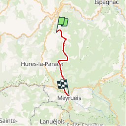
Trail Walking of 21 km to be discovered at Occitania, Lozère, Mas-Saint-Chély. This trail is proposed by bouscaillou.
Positioning
Country:
France
Region :
Occitania
Department/Province :
Lozère
Municipality :
Mas-Saint-Chély
Location:
Unknown
Start:(Dec)
Start:(UTM)
531530 ; 4906205 (31T) N.
Comments