


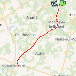
Aller-retour Laval à Cossé le Vivien

phimar_2612
User

Length
27 km

Max alt
103 m

Uphill gradient
212 m
Km-Effort
30 km

Min alt
59 m

Downhill gradient
212 m
Boucle
Yes
Creation date :
2019-09-19 09:15:28.01
Updated on :
2019-09-19 16:05:10.482
5h09
Difficulty : Easy

FREE GPS app for hiking
 SityTrail
IGN / Geographical institutes
SityTrail Plus
The world is yours!
About
Trail Walking of 27 km to be discovered at Pays de la Loire, Mayenne, Montigné-le-Brillant. This trail is proposed by phimar_2612.
Description
En suivant l'ancienne voie ferrée
Positioning
Country:
France
Region :
Pays de la Loire
Department/Province :
Mayenne
Municipality :
Montigné-le-Brillant
Location:
Unknown
Start:(Dec)
Start:(UTM)
663331 ; 5322010 (30U) N.
Comments