


chars

Grouchat
User
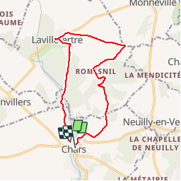

Length
12.9 km

Max alt
129 m

Uphill gradient
188 m
Km-Effort
15.5 km

Min alt
61 m

Downhill gradient
197 m
Boucle
No
Creation date :
2019-09-20 07:46:12.753
Updated on :
2019-09-20 13:34:38.93
3h54
Difficulty : Easy

FREE GPS app for hiking
 SityTrail
IGN / Geographical institutes
SityTrail Plus
The world is yours!
About
Trail Walking of 12.9 km to be discovered at Ile-de-France, Val-d'Oise, Chars. This trail is proposed by Grouchat.
Positioning
Country:
France
Region :
Ile-de-France
Department/Province :
Val-d'Oise
Municipality :
Chars
Location:
Unknown
Start:(Dec)
Start:(UTM)
422378 ; 5446080 (31U) N.
Comments