


ST KIBE Jeizinen

Cornelius
User
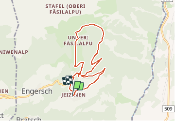

Length
7.6 km

Max alt
2096 m

Uphill gradient
576 m
Km-Effort
15.2 km

Min alt
1520 m

Downhill gradient
553 m
Boucle
Yes
Creation date :
2014-12-11 00:00:00.0
Updated on :
2014-12-11 00:00:00.0
--
Difficulty : Unknown

FREE GPS app for hiking
 SityTrail
IGN / Geographical institutes
SityTrail Plus
The world is yours!
About
Trail Other activity of 7.6 km to be discovered at Valais/Wallis, Leuk, Gampel-Bratsch. This trail is proposed by Cornelius.
Description
Mittelschwere Skitour für KIBE
Positioning
Country:
Switzerland
Region :
Valais/Wallis
Department/Province :
Leuk
Municipality :
Gampel-Bratsch
Location:
Unknown
Start:(Dec)
Start:(UTM)
401689 ; 5131115 (32T) N.
Comments