


Rayol Canadel - Panoramique de Malatra

soca
User
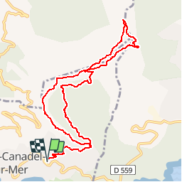

Length
11.5 km

Max alt
485 m

Uphill gradient
484 m
Km-Effort
18 km

Min alt
84 m

Downhill gradient
484 m
Boucle
Yes
Creation date :
2019-09-22 10:14:08.629
Updated on :
2019-09-22 10:15:29.225
4h30
Difficulty : Medium

FREE GPS app for hiking
 SityTrail
IGN / Geographical institutes
SityTrail Plus
The world is yours!
About
Trail On foot of 11.5 km to be discovered at Provence-Alpes-Côte d'Azur, Var, Rayol-Canadel-sur-Mer. This trail is proposed by soca.
Positioning
Country:
France
Region :
Provence-Alpes-Côte d'Azur
Department/Province :
Var
Municipality :
Rayol-Canadel-sur-Mer
Location:
Unknown
Start:(Dec)
Start:(UTM)
295133 ; 4781604 (32T) N.
Comments