


randonnée des clochers

Steph0726
User

Length
17 km

Max alt
425 m

Uphill gradient
354 m
Km-Effort
22 km

Min alt
232 m

Downhill gradient
355 m
Boucle
Yes
Creation date :
2019-09-22 07:52:05.101
Updated on :
2019-09-22 13:42:06.861
5h48
Difficulty : Easy

FREE GPS app for hiking
 SityTrail
IGN / Geographical institutes
SityTrail Plus
The world is yours!
About
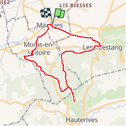
Trail Walking of 17 km to be discovered at Auvergne-Rhône-Alpes, Drôme, Manthes. This trail is proposed by Steph0726.
Positioning
Country:
France
Region :
Auvergne-Rhône-Alpes
Department/Province :
Drôme
Municipality :
Manthes
Location:
Unknown
Start:(Dec)
Start:(UTM)
657385 ; 5018528 (31T) N.
Comments