


Siou Blanc - Aiguilles de Valbelle -

soca
User
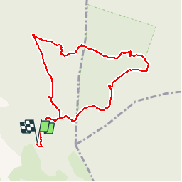

Length
10 km

Max alt
644 m

Uphill gradient
272 m
Km-Effort
13.6 km

Min alt
442 m

Downhill gradient
272 m
Boucle
Yes
Creation date :
2019-09-22 15:23:36.288
Updated on :
2019-09-22 15:24:47.709
3h20
Difficulty : Medium

FREE GPS app for hiking
 SityTrail
IGN / Geographical institutes
SityTrail Plus
The world is yours!
About
Trail On foot of 10 km to be discovered at Provence-Alpes-Côte d'Azur, Var, Signes. This trail is proposed by soca.
Positioning
Country:
France
Region :
Provence-Alpes-Côte d'Azur
Department/Province :
Var
Municipality :
Signes
Location:
Unknown
Start:(Dec)
Start:(UTM)
737135 ; 4790595 (31T) N.
Comments