


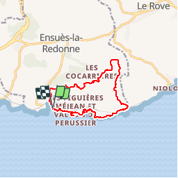
Port la Redonne - Calanque de l'Everine - Plaine du Sui

soca
User

Length
13.4 km

Max alt
226 m

Uphill gradient
437 m
Km-Effort
19.2 km

Min alt
0 m

Downhill gradient
430 m
Boucle
Yes
Creation date :
2019-09-22 19:06:20.826
Updated on :
2019-09-22 19:08:36.637
5h00
Difficulty : Medium

FREE GPS app for hiking
 SityTrail
IGN / Geographical institutes
SityTrail Plus
The world is yours!
About
Trail On foot of 13.4 km to be discovered at Provence-Alpes-Côte d'Azur, Bouches-du-Rhône, Ensuès-la-Redonne. This trail is proposed by soca.
Positioning
Country:
France
Region :
Provence-Alpes-Côte d'Azur
Department/Province :
Bouches-du-Rhône
Municipality :
Ensuès-la-Redonne
Location:
Unknown
Start:(Dec)
Start:(UTM)
678339 ; 4800055 (31T) N.
Comments