


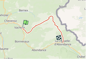
Chasseresse-Darbon-Bise-chapelle

svp59
User

Length
17.7 km

Max alt
1957 m

Uphill gradient
1474 m
Km-Effort
37 km

Min alt
834 m

Downhill gradient
1291 m
Boucle
No
Creation date :
2014-12-10 00:00:00.0
Updated on :
2014-12-10 00:00:00.0
7h33
Difficulty : Medium

FREE GPS app for hiking
 SityTrail
IGN / Geographical institutes
SityTrail Plus
The world is yours!
About
Trail Walking of 17.7 km to be discovered at Auvergne-Rhône-Alpes, Upper Savoy, Vacheresse. This trail is proposed by svp59.
Positioning
Country:
France
Region :
Auvergne-Rhône-Alpes
Department/Province :
Upper Savoy
Municipality :
Vacheresse
Location:
Unknown
Start:(Dec)
Start:(UTM)
320876 ; 5132856 (32T) N.
Comments