


plancher les mines

gerard70
User
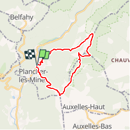

Length
11.6 km

Max alt
1129 m

Uphill gradient
715 m
Km-Effort
21 km

Min alt
492 m

Downhill gradient
720 m
Boucle
Yes
Creation date :
2019-09-26 15:23:31.017
Updated on :
2019-09-26 15:24:59.739
--
Difficulty : Difficult

FREE GPS app for hiking
 SityTrail
IGN / Geographical institutes
SityTrail Plus
The world is yours!
About
Trail On foot of 11.6 km to be discovered at Bourgogne-Franche-Comté, Haute-Saône, Plancher-les-Mines. This trail is proposed by gerard70.
Positioning
Country:
France
Region :
Bourgogne-Franche-Comté
Department/Province :
Haute-Saône
Municipality :
Plancher-les-Mines
Location:
Unknown
Start:(Dec)
Start:(UTM)
330833 ; 5292304 (32T) N.
Comments