


Siou Blanc_aiguilles de Valbelle

bernir
User
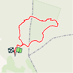

Length
8.9 km

Max alt
635 m

Uphill gradient
237 m
Km-Effort
12 km

Min alt
442 m

Downhill gradient
236 m
Boucle
Yes
Creation date :
2019-09-26 08:21:22.835
Updated on :
2019-09-27 09:11:23.808
7h05
Difficulty : Easy

FREE GPS app for hiking
 SityTrail
IGN / Geographical institutes
SityTrail Plus
The world is yours!
About
Trail On foot of 8.9 km to be discovered at Provence-Alpes-Côte d'Azur, Var, Signes. This trail is proposed by bernir.
Positioning
Country:
France
Region :
Provence-Alpes-Côte d'Azur
Department/Province :
Var
Municipality :
Signes
Location:
Unknown
Start:(Dec)
Start:(UTM)
737213 ; 4790539 (31T) N.
Comments