


randogps49-216

bubuserge
User
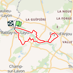

Length
12.5 km

Max alt
93 m

Uphill gradient
199 m
Km-Effort
15.2 km

Min alt
23 m

Downhill gradient
199 m
Boucle
Yes
Creation date :
2019-09-27 19:18:11.445
Updated on :
2019-09-27 19:20:05.89
3h17
Difficulty : Difficult

FREE GPS app for hiking
 SityTrail
IGN / Geographical institutes
SityTrail Plus
The world is yours!
About
Trail Walking of 12.5 km to be discovered at Pays de la Loire, Maine-et-Loire, Bellevigne-en-Layon. This trail is proposed by bubuserge.
Positioning
Country:
France
Region :
Pays de la Loire
Department/Province :
Maine-et-Loire
Municipality :
Bellevigne-en-Layon
Location:
Unknown
Start:(Dec)
Start:(UTM)
683136 ; 5241015 (30T) N.
Comments