


rdn

JeanPierreNancy
User
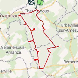

Length
20 km

Max alt
283 m

Uphill gradient
247 m
Km-Effort
24 km

Min alt
223 m

Downhill gradient
248 m
Boucle
Yes
Creation date :
2019-09-27 21:10:24.146
Updated on :
2019-09-30 08:53:25.273
5h36
Difficulty : Medium

FREE GPS app for hiking
 SityTrail
IGN / Geographical institutes
SityTrail Plus
The world is yours!
About
Trail Walking of 20 km to be discovered at Grand Est, Meurthe-et-Moselle, Champenoux. This trail is proposed by JeanPierreNancy.
Positioning
Country:
France
Region :
Grand Est
Department/Province :
Meurthe-et-Moselle
Municipality :
Champenoux
Location:
Unknown
Start:(Dec)
Start:(UTM)
304994 ; 5402324 (32U) N.
Comments