


Plateau saint Julien

pconte
User
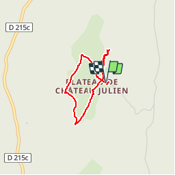

Length
2.8 km

Max alt
1554 m

Uphill gradient
68 m
Km-Effort
3.7 km

Min alt
1507 m

Downhill gradient
71 m
Boucle
Yes
Creation date :
2019-09-29 09:08:16.0
Updated on :
2019-09-29 11:12:30.576
1h15
Difficulty : Easy

FREE GPS app for hiking
 SityTrail
IGN / Geographical institutes
SityTrail Plus
The world is yours!
About
Trail Walking of 2.8 km to be discovered at Auvergne-Rhône-Alpes, Isère, Villard-de-Lans. This trail is proposed by pconte.
Positioning
Country:
France
Region :
Auvergne-Rhône-Alpes
Department/Province :
Isère
Municipality :
Villard-de-Lans
Location:
Unknown
Start:(Dec)
Start:(UTM)
695838 ; 4991379 (31T) N.
Comments