


Essômes sur Marne du 29/09/2019

VANDERPUTTENMi
User GUIDE
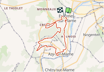

Length
16.5 km

Max alt
207 m

Uphill gradient
339 m
Km-Effort
21 km

Min alt
60 m

Downhill gradient
339 m
Boucle
Yes
Creation date :
2019-09-29 07:21:33.827
Updated on :
2020-02-26 13:27:47.633
4h39
Difficulty : Very easy

FREE GPS app for hiking
 SityTrail
IGN / Geographical institutes
SityTrail Plus
The world is yours!
About
Trail Walking of 16.5 km to be discovered at Hauts-de-France, Aisne, Essômes-sur-Marne. This trail is proposed by VANDERPUTTENMi.
Photos

Positioning
Country:
France
Region :
Hauts-de-France
Department/Province :
Aisne
Municipality :
Essômes-sur-Marne
Location:
Unknown
Start:(Dec)
Start:(UTM)
527151 ; 5430961 (31U) N.
Comments