


Prunet

pb07
User
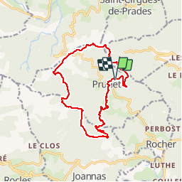

Length
15.4 km

Max alt
889 m

Uphill gradient
565 m
Km-Effort
23 km

Min alt
466 m

Downhill gradient
567 m
Boucle
Yes
Creation date :
2019-09-30 07:55:10.276
Updated on :
2019-09-30 13:39:41.514
5h00
Difficulty : Very easy

FREE GPS app for hiking
 SityTrail
IGN / Geographical institutes
SityTrail Plus
The world is yours!
About
Trail Walking of 15.4 km to be discovered at Auvergne-Rhône-Alpes, Ardèche, Prunet. This trail is proposed by pb07.
Positioning
Country:
France
Region :
Auvergne-Rhône-Alpes
Department/Province :
Ardèche
Municipality :
Prunet
Location:
Unknown
Start:(Dec)
Start:(UTM)
600323 ; 4939074 (31T) N.
Comments