


fleurines

pvmart
User
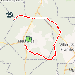

Length
11.5 km

Max alt
152 m

Uphill gradient
180 m
Km-Effort
13.9 km

Min alt
102 m

Downhill gradient
184 m
Boucle
No
Creation date :
2019-10-01 07:37:44.021
Updated on :
2019-10-01 10:53:25.638
3h14
Difficulty : Very easy

FREE GPS app for hiking
 SityTrail
IGN / Geographical institutes
SityTrail Plus
The world is yours!
About
Trail Walking of 11.5 km to be discovered at Hauts-de-France, Oise, Fleurines. This trail is proposed by pvmart.
Positioning
Country:
France
Region :
Hauts-de-France
Department/Province :
Oise
Municipality :
Fleurines
Location:
Unknown
Start:(Dec)
Start:(UTM)
469812 ; 5456031 (31U) N.
Comments