


LP80_LECROTOY- Pt TOUR BASSIN de CHASSE_RS3.6Km

BAIE de SOMME & alentours
Autour de la Baie à pieds
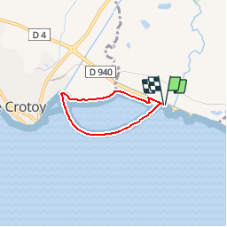

Length
3.6 km

Max alt
6 m

Uphill gradient
10 m
Km-Effort
3.7 km

Min alt
0 m

Downhill gradient
10 m
Boucle
Yes
Creation date :
2019-10-01 16:27:59.113
Updated on :
2019-11-01 10:07:02.859
49m
Difficulty : Easy

FREE GPS app for hiking
 SityTrail
IGN / Geographical institutes
SityTrail Plus
The world is yours!
About
Trail Walking of 3.6 km to be discovered at Hauts-de-France, Somme, Favières. This trail is proposed by BAIE de SOMME & alentours.
Description
Boucle "Rando Santé"
Photos


Positioning
Country:
France
Region :
Hauts-de-France
Department/Province :
Somme
Municipality :
Favières
Location:
Unknown
Start:(Dec)
Start:(UTM)
403891 ; 5563592 (31U) N.
Comments