


trigance pont du tusset rancoumas entrevergue trigance

clintest
User
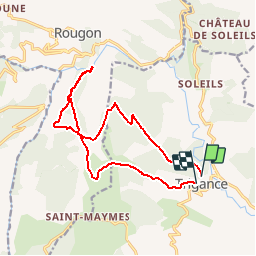

Length
15.8 km

Max alt
1156 m

Uphill gradient
892 m
Km-Effort
28 km

Min alt
624 m

Downhill gradient
883 m
Boucle
No
Creation date :
2019-10-01 19:35:19.164
Updated on :
2019-10-01 19:36:26.038
--
Difficulty : Difficult

FREE GPS app for hiking
 SityTrail
IGN / Geographical institutes
SityTrail Plus
The world is yours!
About
Trail On foot of 15.8 km to be discovered at Provence-Alpes-Côte d'Azur, Var, Trigance. This trail is proposed by clintest.
Positioning
Country:
France
Region :
Provence-Alpes-Côte d'Azur
Department/Province :
Var
Municipality :
Trigance
Location:
Unknown
Start:(Dec)
Start:(UTM)
294351 ; 4848720 (32T) N.
Comments