


Issambres vivier romain 2 octobre 2019

rlebasque
User
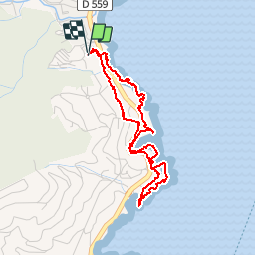

Length
4.2 km

Max alt
24 m

Uphill gradient
54 m
Km-Effort
4.9 km

Min alt
0 m

Downhill gradient
55 m
Boucle
Yes
Creation date :
2019-10-02 15:04:07.186
Updated on :
2019-10-02 16:46:53.357
1h41
Difficulty : Very easy

FREE GPS app for hiking
 SityTrail
IGN / Geographical institutes
SityTrail Plus
The world is yours!
About
Trail Walking of 4.2 km to be discovered at Provence-Alpes-Côte d'Azur, Var, Roquebrune-sur-Argens. This trail is proposed by rlebasque.
Positioning
Country:
France
Region :
Provence-Alpes-Côte d'Azur
Department/Province :
Var
Municipality :
Roquebrune-sur-Argens
Location:
Unknown
Start:(Dec)
Start:(UTM)
314625 ; 4803856 (32T) N.
Comments