


arville poix st hubert monument albert

japy54
User GUIDE
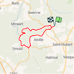

Length
20 km

Max alt
548 m

Uphill gradient
395 m
Km-Effort
26 km

Min alt
285 m

Downhill gradient
395 m
Boucle
Yes
Creation date :
2019-10-03 06:28:05.534
Updated on :
2019-10-03 11:45:27.952
4h45
Difficulty : Medium

FREE GPS app for hiking
 SityTrail
IGN / Geographical institutes
SityTrail Plus
The world is yours!
About
Trail Walking of 20 km to be discovered at Wallonia, Luxembourg, Saint-Hubert. This trail is proposed by japy54.
Positioning
Country:
Belgium
Region :
Wallonia
Department/Province :
Luxembourg
Municipality :
Saint-Hubert
Location:
Saint-Hubert
Start:(Dec)
Start:(UTM)
668604 ; 5547198 (31U) N.
Comments