


RS-Thodure-Le Rival

raymondfn
User
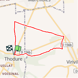

Length
6.8 km

Max alt
373 m

Uphill gradient
93 m
Km-Effort
8 km

Min alt
298 m

Downhill gradient
93 m
Boucle
Yes
Creation date :
2019-10-03 12:16:23.095
Updated on :
2019-10-03 12:25:21.625
1h45
Difficulty : Medium

FREE GPS app for hiking
 SityTrail
IGN / Geographical institutes
SityTrail Plus
The world is yours!
About
Trail Walking of 6.8 km to be discovered at Auvergne-Rhône-Alpes, Isère, Thodure. This trail is proposed by raymondfn.
Description
Rando Santé
Positioning
Country:
France
Region :
Auvergne-Rhône-Alpes
Department/Province :
Isère
Municipality :
Thodure
Location:
Unknown
Start:(Dec)
Start:(UTM)
670015 ; 5020549 (31T) N.
Comments