


les v.forges.201910.03

trusgnachjf
User
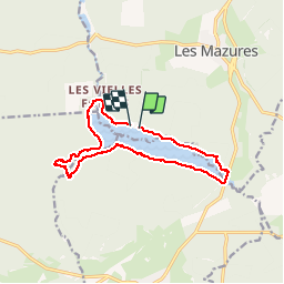

Length
12.3 km

Max alt
270 m

Uphill gradient
109 m
Km-Effort
13.7 km

Min alt
238 m

Downhill gradient
112 m
Boucle
Yes
Creation date :
2019-10-03 11:49:00.76
Updated on :
2019-10-03 14:41:16.594
2h51
Difficulty : Very easy

FREE GPS app for hiking
 SityTrail
IGN / Geographical institutes
SityTrail Plus
The world is yours!
About
Trail Walking of 12.3 km to be discovered at Grand Est, Ardennes, Les Mazures. This trail is proposed by trusgnachjf.
Positioning
Country:
France
Region :
Grand Est
Department/Province :
Ardennes
Municipality :
Les Mazures
Location:
Unknown
Start:(Dec)
Start:(UTM)
615104 ; 5525706 (31U) N.
Comments